Digital Surrounding Maps
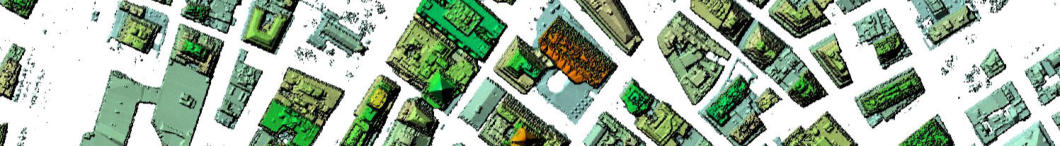
The source for our 3D and 2D maps are high-resolution, most recent satellite and aerial imagery.
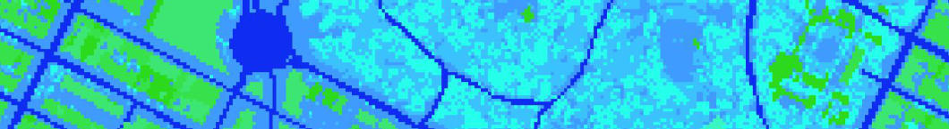
Our geo-data includes (but is not limited to):
1. 3D building, 3D vegetation, 3D bridge high fidelity vectors
2. Land use classification or clutter mapping or any resolution
3. Terrain maps of any resolution
4. Clutter heights of any resolution
The complexity of the IoT (fixed location often indoor devices) and the upcoming 5G networks
(mmWave frequencies) require a different approach for design, optimization and cost analysis.
Any reliable analysis and task automation on wireless networks deeply depends on the estimation of
the path between transmitter and receiver also indoor. Such task is possible by using the top-quality
mapping data that also must be more frequently updated.
To enable high accuracy geo-analytics, we produce several types of GEO data from basis terrain and
land use maps to highly specialized thematic geo-data. We offer the flexible type of licensing including
perpetual and subscription based licenses.
Our high quality 2D and 3D data can be customized for multiple purposes including commercial communication systems design (cellular,
wireless, transmission backbone planning, traffic density), Public Safety systems’ network design and coverage planning and government
agencies (geo-analytics services such as high-resolution crime rate mapping, accidents density, population density etc.)
High Quality Digital Mapping
Thematic Digital Maps
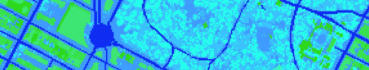
High Quality Digital Mapping


The complexity of the IoT (fixed location often indoor devices) and the
upcoming 5G networks (mmWave frequencies) require a different
approach for design, optimization and cost analysis.
Any reliable analysis and task automation on wireless networks deeply
depends on the estimation of the path between transmitter and receiver
also indoor. Such task is possible by using the top-quality mapping data
that also must be more frequently updated.
To enable high accuracy geo-analytics, we produce several types of GEO
data from basis terrain and land use maps to highly specialized thematic
geo-data. We offer the flexible type of licensing including perpetual and
subscription based licenses.
Digital Surrounding Maps
The source for our 3D and 2D maps are high-resolution, most recent satellite
and aerial imagery.
Our geo-data includes (but is not limited to):
1. 3D building, 3D vegetation, 3D bridge high fidelity vectors
2. Land use classification or clutter mapping or any resolution
3. Terrain maps of any resolution
4. Clutter heights of any resolution
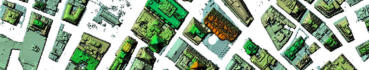
Thematic Digital Maps
Our high quality 2D and 3D data can be customized for multiple purposes
including commercial communication systems design (cellular, wireless,
transmission backbone planning, traffic density), Public Safety systems’
network design and coverage planning and government agencies
(geo-analytics services such as high- resolution crime rate mapping, accidents
density, population density etc.)